Mountain bike vacation in Samnaun
Our motto this year - cycling with calves!
Mountain biking in the immediate surroundings. Pure nature - your personal effort is required. For flatland bikers we offer the possibility to be chauffeured to the suitable bike route and to be picked up again at the arranged meeting point. Route plans are available in your mountain bike vacation Samnaun and can also be discussed on site.

Free transport of bikes with the mountain railroads Samnaun! The transport of mountain bikes with the cable car and the chairlifts is possible. During the summer season the cable car runs from 08.00 - 12.00 and from 13.00 - 17.00 every half hour. Mountain bikes can also be transported on the post buses, but advance reservations (especially on the Martina - Samnaun route) are required. Information is available from the post bus office in Scuol, tel. +41 81 864 16 83.
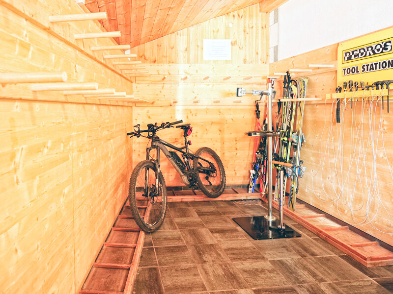
Repair facilities
We offer repair facilities for motorcycles and mountain bikes for your cycling vacation in the Samnaun mountains. Here you will find special tools as well as a bike holder. There is also a separate washing area as well as secure storage facilities in a locked room. Enjoy the mountain summer
Guided mountain bike tours in Samnaun
Mountain bike tours in Samnaun are offered once a week on request by the Samnaun Tourist Board. The duration varies depending on the group composition and the tour. The tour itself is arranged according to the wishes of the participants and participation is free of charge. However, registration with Samnaun Tourism is obligatory. For more information please contact Samnaun Tourism.
- keyboard_arrow_rightMTB tours EASY
Samnaun - Compatsch
Start: Samnaun-Dorf
Destination: Compatsch at the saw mill
Difference in altitude: 175 m
Length: 4.0 km
Terrain: Road without hard surface
Route description: The trail starts below the Chasa Riva (Samnaun Tourism) through the Samnaun valley. Past the tennis court to the bridge in Ravaisch. From here continue across the parking lot of the aerial cableway valley station and along the Schergenbach untiol you reach the bridge at Plan. Past the local museum "Chesa Retica" (under homeland security) and then on the old valley road to Laret, where the valley side is again changed, the trail leads to the saw mill in Compatsch.Laret - MotGrond
Start: Samnaun Laret
Destination: Mot Grond
Difference in altitude: 107 m
Length: 2.1 km
Terrain: Road without hard surface
Route description: After a short descent from the tour start in Laret and the crossing of the road the forest trail slopes up towards Clis Grond. There, the route divides and the trail leads left slightly uphill to Mot Grond. This route is especially suited for beginners and families. At teh end of the route there is a barbecue place that invites to rest and linger.Samnaun Compatsch - Spissermühle
Start: Samnaun Compatsch
Destination: Spissermühle
Difference in altitude: 262 m
Length: 5.2 km
Terrain: Road without hard surface
Route description: After the start in Compatsch the winding route leads with a leisurely slope to Val Scüra. There you have a wonderful view of the Zanderstal and the Mutterköpfl. Shortly after entering the Zanderstal, a trail at the left side at the playground turns down the valley. After an easy downhill route you reach the Spissermühle near the border crossing and the customs.Samnaun Compatsch Spiss
Start: Samnaun Compatsch Destination: Spissermühle Difference in altitude: 262 mLength: 5.2 km Terrain: Road without hard surfaceRoute descriptionAfter the start in Compatsch the winding route leads with a leisurely slope to Val Scüra. There you have a wonderful view of the Zanderstal and the Mutterköpfl. Shortly after entering the Zanderstal, a trail at the left side at the playground turns down the valley. After an easy downhill route you reach the Spissermühle near the border crossing and the customs.Idalpe - Ischgl
Start: Samnaun Compatsch
Destination: Spiss
Difference in altitude: 21 m
Length: 5.2 km
Terrain: Road without hard surface
Route description: After the first rise from Ischgl the first waypoint is the Pardatschalpe. From there the trail slopes up leisurely but constantly through the Fimbatal towards the Bodenalpe (stop for refreshments). After a further ascent, past the Gampenalp (stop for refeshments, extra path) the biker reaches the Fimberalpe at 2,123 m. Afterwards, you continue along the stream into Val Fenga to finally reach the Heidelberger Hütte (refreshments and accommodation) - keyboard_arrow_rightMTB tours MEDIUM
Samnaun - Val Motnaida
Start: Samnaun-Dorf
Destination: Val Motnaida
Difference in altitude: 260 m
Length: 4.0 km
Terrain: Road without hard surface
Route description: At the entrance of Val Maisas the forest road starts towards Salantinas. After 2 switchbacks the road winds continuously towards Motta Saltuorn. All the way you can enjoy fantastic views of the Samnauntal with its fractions Samnaun-Dorf, Ravaisch, Plan, Laret and Compatsch. On the way there is a little, non farmed forest hut that invites for a rest. From the hut a trail leads further until you reach your destination in Val Motnaida.Samnaun Laret - Ché D'Mot
Start: Samnaun Laret
Destination: below Ché d'Mot
Difference in altitude: 302 m
Length: 2.1 km
Terrain: Road with and without hard surface
Route description: Next to the fraction Laret the road starts slightly sloping up towards Plan. Above Plan, near Salaatsch, the road branches off to Tischanaderet. An ascending slope follows until the road divides towards Planer Salaas / Alp Trida Sattel and Ché d'Mot. From there the road slopes up at the left to a hill at 2,014 m.Alp Trida Sattel - Samnaun Compatsch
Start: Alp Trida Sattel
Destination: Samnaun Compatsch
Difference in altitude: 795 m Length: 5.9 km
Terrain: partly road, partly field path
Route description: After a ride with the Doppelstockbahn to the top station at the Alp Trida Saddle a racy downhill run to the Alp Trida awaits the bikers. A moderate descent to the Unteralp follows. The final part, past the Alpstein, leads back to Compatsch where the route ends behind the parish church St. Jakobus.Ischgl - Heidelberger Hütte
Start: Ischgl
Destination: Heidelberger hut
Difference in altitude: 928 m
Length: 14.5 km
Terrain: partly road, partly field path
Route description: After the first rise from Ischgl the first waypoint is the Pardatschalpe. From there the trail slopes up leisurely but constantly through the Fimbatal towards the Bodenalpe (stop for refreshments). After a further ascent, past the Gampenalp (stop for refeshments, extra path) the biker reaches the Fimberalpe at 2,123 m. Afterwards, you continue along the stream into Val Fenga to finally reach the Heidelberger Hütte (refreshments and accommodation).Zeblasjoch - Ischgl
Start: Zeblasjoch
Destination: Ischgl
Difference in altitude: 1,203 m
Length: 12.5 km
Terrain: partly road, partly field path
Route description: After the start on the Zeblasjoch a descent leads down to the Gampenalpe (stop for refreshments). At the Gampenalp tthe road divides in the Fimbatal towards the Heidelberger Hütte and the Bodenalpe. The road continues on the right downhill past the Bodenalpe (stop for refreshments) to the Pardatschalpe. A road leads under the cable cars to the Velillbach. Continue left at the branch-off to the final descent part down to Ischgl. - keyboard_arrow_rightMTB tours DIFFICULT
Samnaun - Zeblasjoch
Start: Samnaun-Dorf
Destination: Zeblasjoch
Difference in altitude: 699 m
Length: 4.5 km
Terrain: road without hard surface
Route description: The road starts at the end of Samnaun-Dorf where the forest road starts from Val Musauna. After a leisurely slope at the beginning the route becomes steeper at the start of the first serpentines. The road continues through a narrow and deep gorge to the Zeblaswiesen at 2,404 m. From there the valley gets wider and offers many beautiful views of the Samnauner mountains. After further 135 m in height you reach the tour destination Zeblasjoch.Samnaun Laret - Forstweg Churschiglias
Start: Samnaun Laret
Destination: Curschglias
Difference in altitude: 406 m
Length: 2.1 km
Terrain: road without hard surface
Route description: After a short descent from the tour start in Laret and the crossing of the road the forest road slopes up towards Clis Grond. From there the road divides into 3 different directions. The route to Fuorcla Curschiglias turns right and rises up to 2,137 m. At the destination Fuorcla Curschiglias you can enjoy a fantastic panorama view of the Samnauner mountains and the Oetztaler Alps.Samnaun Compatsch - Alp Trida Sattel
Start: Samnaun Compatsch
Destination: Alp Trida Sattel
Difference in altitude: 795 m
Length: 5.9 km
Terrain: partly road, partly field path
Route description: Behind the church in Samnaun Compatsch the road starts slightly rising into the valley towards Alp Bella. After a short time you reach the Unteralp with the Alpstein, one of the largest erratic block in Switzerland. The road continues until it divides shortly before the Oberalp. Between the Oberalp on the right and the Piz Munschuns on the left side the road leads further with a slight slope to the Skihaus Alp Trida. There you can stop for a rest and refreshments. From there the road leads across the Alp Trida up to the top station of the Doppelstockbahn, stop for a rest at the Panorama Restaurant Alp Trida Sattel.Samnaun Compatsch - Fliesser Alpe
Start: Samnaun Compatsch
Destination: Fliesser Alpe
Difference in altitude: 301 m
Length: 5.0 km Terrain: road without hard surface
Route description: After the start in Compatsch the winding road leads with a leisurely slope until Val Scüra. From there you have a great view of the Zanderstal and the Mutterköpfl. After a descent into the Zanderstal the road turns left uphill towards the Fliesser Alpe. From there the road continuously slopes up past the Zanderswiesen until you reach your destination Fliesser Alpe.Pfandshof (Acla da Fans) - Val Sampuoir
Start: Pfandshof
Destination: Las Era
Difference in altitude: 587 m
Length: 9.6 km
Terrain: road with and without hard surface
Route description: From the Pfandshof (Acla da Fans) the route runs along the road Samnaun - Vinadi. Shortly after the first natural tunnel a small path on the right side leads into Val Sampoir. After a long ascent you first reach Plan Got Nair and then your destination Las Era at 2,094 m. From there you have a wonderful view of the Muttler.